Trent Navigation Company, 1780-1934
A History
Waterways in the Midlands up to 1783
The River Trent runs from just north of Stoke-on-Trent in Staffordshire, past Burton upon Trent, Nottingham, Newark and Gainsborough, to its junction with the River Humber at Trent Falls. In the days before paved roads, it provided an invaluable means of transportation of people and goods.
The first Act of Parliament concerning navigation on the River Trent, 'An Act for making and keeping the river Trent, in the counties of Leicester, Derby and Stafford, navigable', was passed in 1699. This provided for maintaining the navigation up to Burton upon Trent, and granted tolls to the Earl of Uxbridge or his lessees. A further Act of 1770, 'An Act for the better regulating the Navigation of the River Trent from Wilden Ferry, otherwise Cavendish Bridge, in the County of Derby, to Gainsborough, in the County of Lincoln', ordered all barges or other vessels to be numbered and marked with the name and residence of their owner.
In the 1760s, plans were laid by various companies to cut canals in the Midlands to intersect with the River Trent and extend navigation into other areas. The canal which had most effect on the River Trent was the Trent and Mersey Canal, which enabled boats to travel directly from the west coast to the east coast of England. It ran from the River Trent at Wilden Ferry near Shardlow in Derbyshire, to the River Mersey at Liverpool. It opened in 1777 and immediately proved much more popular than the Upper Trent between Wilden Ferry and Burton upon Trent.
Downstream, the Chesterfield Canal also opened in 1777. This allowed goods to be transported from Chesterfield, Worksop and Retford to the River Trent at West Stockwith. The River Soar Navigation, also known as the Loughborough Canal, was opened in 1778 between the town of Loughborough and the River Trent near Long Eaton. The following year, the Erewash Canal was opened, which headed north from the River Trent at Long Eaton to Langley Mill in Derbyshire. This canal was used to transport coal from the Derbyshire coalfields.
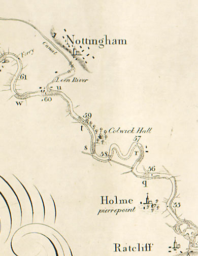
Detail from map of the River Trent in 1782 [Em.B8 D82]
Early years of the Trent Navigation Company, 1783-1797
In response to these new canals and the subsequent increase of traffic, the Trent Navigation Company was established by Act of Parliament in 1783, 'An Act for improving the Navigation of the River Trent'. The company was responsible for improving and maintaining the navigation on the River Trent between Wilden Ferry and Gainsborough, and the junctions with the various other canals. The only stretch it was not responsible for was the northern branch of the Trent from Averham to South Muskham, which was run by the Newark Navigation Commission following an Act of Parliament in 1772. The Trent Navigation Company ran the southern branch between the same places, through the town of Newark itself. The first main business tackled by the Company was the building of towpaths, known as haling paths, which generated much correspondence with landowners.
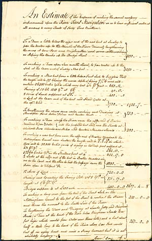
First page of an estimate of expenses in constructing cuts and weirs, n.d. [c.1793] [RtN 423]
Meanwhile, further canals opened in the 1790s, some of which offered alternative routes for water traffic which by-passed large sections of the River Trent. The Loughborough Canal was extended as far as Leicester in 1794. In 1795, the Derby Canal opened, linking the town of Derby to the Erewash Canal at Sandiacre. A further branch opened the following year linking Derby to the River Trent at Swarkestone. The Nottingham Canal, which opened in 1796, ran from the Erewash Canal junction at Langley Mill, which itself linked to the Cromford Canal, down to the River Trent near Trent Bridge in Nottingham. The combination of both canals enabled boats from the Derbyshire coalfields and from the town of Derby to avoid the River Trent between Long Eaton and Nottingham. Finally, the Grantham Canal opened in 1797, running from the River Trent at Nottingham to the town of Grantham.
The competition provided by the Trent and Mersey, Derby and Nottingham canals prompted the Trent Navigation Company to improve their route by cutting canalized sections of their own. These allowed the wide Trent barges to by-pass particularly difficult or shallow stretches of the river. In 1793, a cut was opened at Sawley, and in 1797, the Cranfleet Cut was opened near Trent Lock at Long Eaton. Following an Act of Parliament passed in 1794, 'to alter and amend an Act of the Twenty-third year of his present Majesty, for improving the Navigation of the River Trent...', the Trent Navigation Company built the Beeston Canal, which ran from the Trent at Beeston eastwards to join the Nottingham Canal at Lenton. Boats which used this cut then had to travel along the Nottingham Canal to rejoin the river at Trent Bridge.
The nineteenth century
The river and canal network was more or less completed by the end of the eighteenth century, and business continued until the coming of the railways in the early 1840s. The competition provided by the railways in transporting both goods and passengers between towns and cities forced many canal companies into financial difficulties, and trade along the River Trent was also affected.
A number of Acts of Parliament concerning the Trent Navigation Company were passed in the late nineteenth century. They were mostly concerned with its proper organization. The Trent Navigation Act of 1858 was followed by the Trent Navigation Act of 1884, which incorporated the company. A prospectus was drawn up and shares offered for sale. In 1887, following another Act of Parliament, the Trent Navigation Company was taken over by the Trent (Burton-upon-Trent and Humber) Navigation Company. The Trent Navigation Act of 1892 restored the original company name.
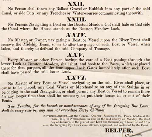
Detail from River Trent Navigation Bye Laws, 1859 [RtN 1338]
The twentieth century
The Trent Navigation Company obtained another Act of Parliament in 1906, authorizing them to make improvements upstream of Newark to allow larger boats to navigate the river. However, they were only able to build one lock at Cromwell before the outbreak of the First World War. By the Nottingham Corporation (Trent Navigation Transfer) Act of 1915, the whole stretch of the Trent from Averham up to Nottingham was put under the control of the city of Nottingham. The Corporation funded £450,000 worth of improvements, completed in 1927, which included a number of new locks and a cut at Holme Lock. The works enabled large river boats to sail up to Nottingham from Hull and the continent, and increased trade four-fold.
In 1937, the bulk of the Nottingham Canal was closed. However, the stretch through Nottingham, from Trent Bridge to the junction with the Beeston Canal at Lenton, was taken over by the Trent Navigation Company.
The Trent Navigation Company ceased to exist in 1940, when it was taken over by the Trent River Catchment Board. The Catchment Board was succeeded in 1951 by the Trent River Board, and in 1965 by the Trent River Authority.
Records
The records came to the University Library in November 1970 from the Trent River Authority.
Multi-level descriptions of the Trent Navigation Company records are available through the Manuscripts Online Catalogue.
The bulk of the collection relates to the first thirty years of the Company's existence, and consists chiefly of reports and correspondence. From 1780 to 1813 the Company's engineer was William Jessop of Butterley, and his reports and correspondence survive in the collection. Most of the letters, reports and other papers were drawn up or collected by the Clerks to the Trent Navigation Company. This role was filled for many years by members of a Newark firm of solicitors, among which were Job Brough, Edward Smith Godfrey and Edward Tallents.
Later items deal with the relationship between the Company and the railways in the 1840s. There are also documents relating to a number of lawsuits in the 1880s which followed the great floods of 1875 and 1877. Finally, there are documents dealing with the opposition of the Trent River Catchment Board to the Navigation Company's last works before it merged with the Board in 1940.
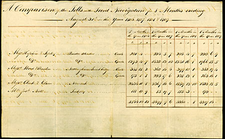
Table of tolls received 1806-1809 [RtN 917]
Next page: City of Nottingham Water Department, 1852-1978