Manvers Estate Map
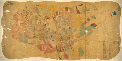
Plan of Earl Manvers’ estate in Laxton and Moorhouse, 1862
From Manvers Collection Ma 5420
This detailed plan accompanied a survey of the 3rd Earl Manvers’ estate by Thomas Huskinson. Earl Manvers had succeeded to the estate two years previously and wished to know what he owned and how it could be improved.
The plan is hand-drawn and colour-coded to show the holdings of each of the Earl’s tenants. Piecemeal enclosures over the previous two centuries had reduced the number of open field strips, but their narrow size and shape is still striking. The colour-coding reveals how the holdings of most farmers were scattered among the open fields and enclosures. Areas left uncoloured represent other landowners’ property, common land and sykes (unworked grassland).
A larger image of this map is available on the Laxton: Living in an Open Field Village resource on the Manuscripts and Special Collections website (Theme 1, Document 15).
More: Map of Laxton Farms c. 1939
Laxton: Farming in an Open Field Village home