Map of Laxton Farms c. 1939
Plan of landholdings in Laxton and Moorhouse, c.1939 (from MS 161)
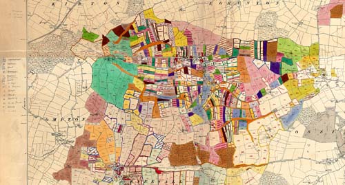
This 1921 Ordnance Survey map, at a scale of six inches to the mile, was colour-coded and annotated by two members of The University of Nottingham, Professor K.C. Edwards (1904-1982) of the Department of Geography, and Professor J.D. Chambers (1898-1970) of the Department of Economic and Social History.
As in the 1862 plan, the enclosures and strips are colour-coded to show each of the separate tenancies. The open fields had been reduced in area and re-organised by Earl Manvers’ agent, R.W. Wordsworth, between 1903 and 1906. This plan shows how much fewer and wider the strips were in comparison to 1862.
More: Landlords and tenants
Laxton: Farming in an Open Field Village home