What can they tell us?
Maps and plans are an invaluable historical source, largely because they act as repositories of information about a particular place or location at the time at which they were compiled. They can serve a variety of purposes, both contemporary and subsequent. They are notable because, in interpreting them, we may learn about the lives of ordinary people - not just the upper, landed classes.
As well as the obvious geographical and topographical information contained in maps and plans, such as the whereabouts of roads, rivers, railway lines, buildings, woodlands and so on, they may also reveal information including: the names of landowners; the names of occupiers; the acreage of land held or owned; descriptions of particular properties; records of the state of cultivation of particular parcels of land; details of the rental value of a property, and so on. This undated map of the parish of Cromwell [c.1807-1821] gives a wealth of information about the parish and its landowners.
![Ne 5 P 8 - Map of the parish of Cromwell, Nottinghamshire; n.d. [c.1807-1821]](/ManuscriptsandSpecialCollections/Images-Multimedia/ResearchGuidance/MapsandPlans/05-1185m.jpg)
Map of the parish of Cromwell, Nottinghamshire; n.d. [c.1807-1821] [Ne 5 P 8]
Maps and plans can also reveal details of how a particular location developed. For example, comparison of two maps of a town or city from different dates may show how it has grown to incorporate a rising population, how people's dwellings have changed (the introduction of tenements, terraces, flats, etc), how the population has moved out to developing suburbs, how (and possibly why) particular industries have centred on an area, how utilities such as gas and electricity have been introduced, how sanitation has been improved, and so on. The Duke of Portland developed the Aldrington estate at Hove, Sussex, in the 1880s, as shown in this plan.
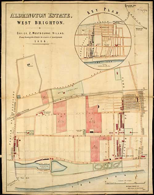
Plan of the Aldrington estate, West Brighton, Sussex; 1884 [Pl E14/7/12]
Maps can provide information about the history of travel - routes which were particularly frequently used, distances between key locations, usual stopping points for breaking journeys, the exploration and discovery of previously uncharted lands and waters, or the introduction of different forms of transport. They can also inform about the history of migration and settlement. This example shows the route of the Great North Road between Tuxford and York in 1719.
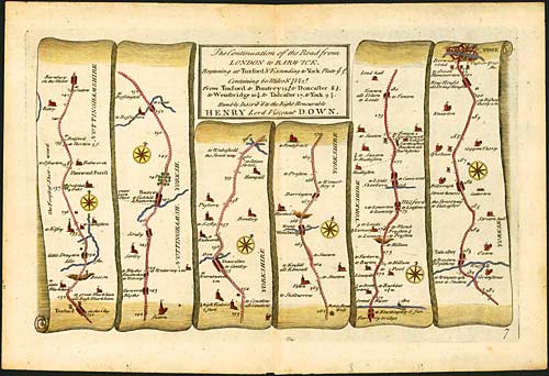
Map of the continuation of the Road from London to Barwick, beginning at Tuxford and extending to York, by John Senex (d. 1740), printed 1719 [Bre 8]
From maps it is possible to learn about when and how natural resources began to be exploited - coal, tin, oil, sand, gravel - and the impact this had on the landscape and on communities. Also, developments in farming and land management techniques can be identified because maps and plans may show where particular crops were being used, whether land was being rotated, where land was being left fallow, where land was planted with trees, where rivers had been diverted, where land had been drained and the like. Plans like this early-twentieth century plan of proposed electrity lines at Shireoaks in Nottinghamshire show the impact of power stations and the development of public utilities.
![Ne 6 P 3/21/12 - Plan of proposed overhead [electricity] lines for Shireoaks village, Nottinghamshire; n.d. [1900-1950]](/ManuscriptsandSpecialCollections/Images-Multimedia/ResearchGuidance/MapsandPlans/05-1186m.gif)
Plan of proposed overhead [electricity] lines for Shireoaks village, Nottinghamshire; n.d. [1900-1950] [Ne 6 P 3/21/12]
Plans can provide the user with a great deal of information about the developing requirements of buildings, the introduction of new construction techniques, changing fashions in architecture, emerging leisure activities - even the introduction of new technologies.
Military and naval maps and plans may tell us a great deal about numbers involved, troop movements, strategies employed, logistical difficulties encountered and overcome, the introduction of new weapons and equipment or the structure of fortifications. This is a map showing the 'Position of the Combined Armies before Sevastopol' in October 1854.
![Ne C 9889/2 - Map showing the 'Position of the Combined Armies before Sevastopol' by Captain E.B. Wesherally[?]; 16 Oct. 1854](/ManuscriptsandSpecialCollections/Images-Multimedia/ResearchGuidance/MapsandPlans/05-1188m.jpg)
Map showing the 'Position of the Combined Armies before Sevastopol' by Captain E.B. Wesherally[?]; 16 Oct. 1854 [Ne C 9889/2]
There is also a great deal to be learned from the decorations which appear around the edges of maps and plans, such as cartouches, vignettes, charts and tables. Cartouches, for example, may sometimes portray images of economic and cultural life within rural or industrial scenes. Vignettes might include images of particular buildings, showing what they looked like from the outside - especially useful if a building has since been demolished. In the example below, Worksop Manor house in Nottinghamshire is shown in a vignette as part of a county map published in 1837. Charts and tables might include lists of names of tenants and landholders, measurements of particular areas of land or details of the distance between places. Decorations might also show details of particularly notable gardens or parks. The list really is long and varied.
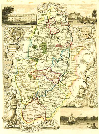
County Map of Nottinghamshire by Thomas Moule (1785-1851), engraved by James Bingley for Moule's 'The English Counties Delineated' [Bre 29]
Next page: Who Might Find Maps and Plans Useful?