
Numerical
Modelling of Bank Erosion in Alluvial River Channels
|
|
 |
Main
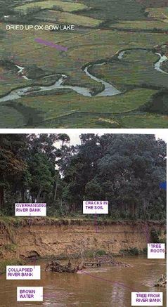
Investigator : Dr N Wright Researcher : Mr A Honarbakhsh Start Date : Oct 1, 1999 Background Riverbank erosion and associated sediment yield is a problem with global significance. Bank erosion along alluvial channels can cause a large number of economic and environmental problems such as land loss, hazards to aquatic habitats, downstream sedimentation, and problems with flood control and navigation. Because of the importance of bank erosion, many attempts have been made to predict riverbank erosion rates and many models have been suggested for this purpose. However, the majority of previous models are limited in that they are empirical and also related to specific areas with particular conditions. These models are not numerically-based models and therefore they are neither able to predict the actual rates of bank erosion nor to simulate the process of bank erosion. The limitation of empirical models is due to the fact that the process of bank erosion is very complex, including fluvial entrainment (erosion by water flow), sediment transport and bank instability. Although some numerical models have been proposed in recent years, none of them can simulate this process completely. The reason for this is that these numerical models are only flow models and or flow and sediment transport models. Moreover, most of these models are one-dimensional and or two-dimensional without any component related to bank stability and secondary current. Since the secondary currents have a major effect on bank erosion, particularly the erosion of outer banks in meandering rivers, their simulation is very important. Because the secondary current is a three-dimensional phenomenon only a three-dimensional model and or a two-dimensional model with a component linked to the secondary current is capable of its simulation. In addition to these problems, many existing numerical models are limited to straight reaches and experimental data, as opposed to real data obtained from rivers. Therefore, this research has focused on the application of three different models: a 3D flow and sediment transport model, a 2D flow and sediment transport model, and a bank stability model. By using these three models, the rates of bank erosion in a meandering river will be predicted. Aims
|