
|
|
| School of Geography | ||
Geographical Information ScienceEarth observation Earth observation by remote sensing is one of the main sources of information on the environment used within GIS. The groups research on Earth observation has pioneered theoretical and practical developments across a wide range of remote sensing and digital image analysis activities. A key focus has been on studies of land cover, with particular regard to thematic mapping at scales ranging from the sub-pixel to global. The group leads the development of techniques for efficient and accurate image classification (Paul Aplin, Doreen Boyd, Giles Foody, Paul Mather, Nick Mount), especially of specific land cover classes which have been used to address NERC funded science questions at a range of scales. The group is also at the forefront of research on precision farming applications and the standardisation of remote sensing systems (Mike Steven), which is fundamental to international priorities on data continuity. Finally, the group has long-term interests on the remote sensing of vegetation stresses. Recently attention has focused on studies of drought in rainforest environments (Doreen Boyd, Giles Foody), the impacts of contamination by radionuclides on forests (Doreen Boyd) and on issues connected with soil gases (Mike Steven). The latter work benefited from recent investment in field facilities for research on leakage of sequestered CO2. The group is also developing biogeographical applications with colleagues in the School (Richard Field, Chris Lavers) with particular interest in the spatial patterns of vegetation determined from analyses of remote sensor data sets.
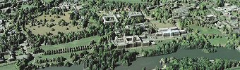
A LiDAR Digital Surface Model (DSM) of University Park Campus draped with aerial photography (data supplied by Infoterra and Getmapping). |
||||