


Research
The SPLINT team is constantly working on the development of new and innovative mobile learning and visualisation technologies. The experience obtained during the evolution and use of the technologies is providing a valuable insight into innovative spatial learning material development.
Each learning technological advancement made by the SPLINT team is rolled out in teaching courses within the university and beyond. The experiences of the students using SPLINT learning objects is then analysed and fed back to the development team in order to create second and third generation technologies, in a student-led technology evolution process.
There will be pedagogic assessments of the merits of the technologies developed and employed during the SPLINT project in comparison with previously employed pedagogic techniques. This research is vital in determining the benefits to our students of the SPLINT spatial technologies.
There are parts of SPLINT development where the underlying technologies under investigation are novel in a teaching and learning context in themselves. One such area is the development of a geographical augmented reality system for use in the field.
Augmented Reality Landscape Visualisations
Recent advancements in Augmented Reality (AR) technology have made AR systems both affordable and mobile enough for use in remote locations.
What is Augmented Reality? Put simply AR is the superimposition of virtual objects over the real world in real time. It can be achieved at several levels. At the highest level it involves the use of either video blending technologies or semi-transparent visors in order to create the superimposition of real and virtual worlds. These technologies are still prohibitively expensive and bulky at the level of purchasing multiple sets of teaching kit.
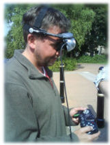
Lower level AR however has evolved into a light and affordable form. This consists of an opaque headset visor which displays a completely virtual world, but in a location and orientation aware manor. This is to say that as the user moves through the real world, and looks around in the real world, the virtual world can track their movements by the use of GPS and motion trackers.
A system such as this allows the user the freedom to look around in a virtual world that mimics the real world outside, but has the potential for transparency showing objects below the ground, augmented objects such as a proposed building development or historic glacial landscapes, overlays such as a geological map on a landscape. In the real world situation a user can raise the visor to compare the virtual with the real in-situ.
SPLINT Geovisionary - For the development of an augmented reality system for use in the field even in rural and remote landscapes, SPLINT at Nottingham worked with the Leicester University team, and Virtalis, a small UK company with a history of development of virtual landscape solutions. Splint at Nottingham acquired 5 full sets of of kit including Dell M90 laptops, Emagin stereo headsets, Saitek wireless controllers, and InertiaCube 3 motion trackers.
Publicity Materials
Download a printable leaflet (.pdf) about recent use of this technology in a field course module "Mobile and Field GIS" on an exercise about Augmenting the Visitor Experience [here]