


Applications
Over the first year of SPLINT much of the time has gone into software familiarisation, and development of the initial virtual field sites. Recently, however, the visualisation suite has become an integral part of the teaching of several modules. Some of the initial teaching and learning uses for the visualisation suite are detailed below:
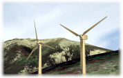
Windfarm Siting Exercise
As part of a masters level module 'Fundamentals of GIS', the students are asked to site a three turbine windfarm within a designated area of the Lake District National Park. They are presented with a host of Geographical Information (GI) data, including satellite imagery, OS MasterMap data, radar terrain data, average wind speed data, planning designation extents, turbine specifications, and asked to use this in their selection process. The students are then asked to give a presentation to staff and peers detailing their reasons for their site selection, for which they may use a combnation of Power Point slides and a representation of their windfarm in-situ in a virtual landscape in the visualisation theatre [more].
Campus Building Modelling Exercise
As part of the 3rd Year Undergraduate/ Masters level module 'Visualisation'. Small groups of students are asked to select and model a building from Nottingham's University Park campus using BOTH: Photomodeler 6.1 (which creates models from multiple digital images using a ground based photogrammetric approach) and Google SketchUp (a 3D CAD and texturing tool to create models for Google Earth). They are given SPLINT's set of digital cameras in order to aquire ground based images of their chosen building, and can also use Google imagery, along with measurement and whatever other useful GI Data sources they could find. Assessment is by a Power Point presentation where they display their models, and attempt to highlight advantages and disadvantages of the two methods.
The SPLINT lab is used after their presentations to display the students' models back to them within the University Campus model. It is set up so that the demonstrator can toggle between their SketchUp and Photomodeller models. The session is used to highlight further advantages and disadvantages between the packages using the differences in the students own models as examples. It is also intended to highlight the problems which are encountered by the demonstrator when it comes to converting their original models into the OpenFlight format required by the stereo projection software in the lab [more].
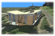
Below is a model of the Portland Building on Nottingham's University Park campus created using Google SketchUp. Click image to rotate model.