


Real-time Landscape Visualisation for Communicating the Location of Windfarms
Real-time 3D Visualisation in Teaching and Learning
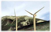
The aim of this project is to embed real-time lab-based visualisation into a GIS-based analysis of potential wind farm locations, undertaken as part of an MSc in GIS group exercise. The main focus of this exercise is the use of GIS to develop a model for suggesting and assessing locations to site a wind farm in an upland area of Northern England. The suggested location, along with a detailed justification, are presented by the groups to their peers and to members of staff at the end of the project. The stereo real-time visualisation facility is made available so students can demonstrate the locations of their wind farms in the broader landscape context. They are able to demonstrate the visibility of the turbines from key locations around the landscape, as may be presented in a public consultation exercise.
Student Experience
Students gain experience of using state-of-the-art real-time visualisation technology to navigate a landscape model built from commercially available RADAR Digital Surface Models, aerial imagery and 3D building and vegetation models. The exercise offers a chance to experience the practicalities of orientation and navigation in a Virtual Reality model.
Ongoing Developments
In order to improve the usability of the visualisation facility certain developments are ongoing, in response to the student experience of interacting with the default system configuration. One such development is a context map synchronised with the 3D display, showing the users’ current position and cone of vision marked on the map.
Summary of the Main Project Aims
- The aim of this project is to explore the use of real-time visualisation in a teaching and learning environment, as a tool to communicate the spatial context of proposed developments on the landscape.
- More specifically the project addresses the following issues:
- Creating a work flow for students to locate 3D wind turbine models on an existing detailed landscape model.
- Enabling students to use the interactive capabilities of a real-time stereo visualisation facility to present their wind farm locations to an audience (of up to 35 people).
- Exploring usability issues in orientation and navigation in a Virtual Reality model.
- Aiming to develop good practice in the use of VR technologies in the student presentation context through the development of extended functionality such as context maps synchronised with the Virtual Reality model.
Publicity Materials
Download a printable leaflet (.pdf) about the project [here]
Contact
If you would like more information about this project please email
andy.burton@nottingham.ac.uk.
If you would like more information about SPLINT developments at Nottingham
in the areas of mobile computing and 3D visualisation then please email gary.priestnall@nottingham.ac.uk.