Engineering Surveying and Remote Measurement
Research activity in this area focuses on improving the potential of technology and its application, including algorithm development, creating novel methodologies, and optimising system performance to solve scientific and engineering challenges. With our strong links outside the University, application projects are also undertaken to transfer knowledge and expertise into industry.
Recent engineering surveying application based projects include:
- bridge monitoring
- highway surveying
- flood risk asset management
- tide gauge and land movement monitoring
- digital surface modelling for flood inundation modelling
- 3D urban modelling
- laboratory engineering model monitoring
These projects require surveying accuracies ranging from millimetres to decimetres and metres.
Research themes
The techniques and technology used to solve the challenges encountered in these projects, will often require novel enhancements to optimise performance. GNSS, laser scanning, photogrammetry, inertial measurement systems, integrated sensors and robotic total stations, form the core technologies supporting this work, from which these current sub-themes arise:
Photogrammetry and Laser Scanning
Photogrammetry and laser scanning are fundamental remote measurement technologies, which have seen major advances over the last few years. The introduction of digital cameras has been a major influence affecting all aspects of the photogrammetric process from data capture to new product developments. See the image opposite (courtesy BLOM Aerofilms Ltd), acquired at a flying height of 1000m with an UltraCamD instrument.
The Institute has had extensive research activities investigating the potential of the latest airborne and terrestrial digital cameras, assessing their data collecting performance and optimising work flows to generate new products, particularly in 3D engineering quality urban and landscape modelling and visualisation. This has taken us into the field of virtual reality and building information management.
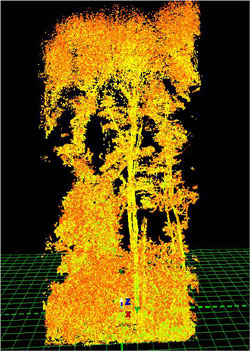
Laser scanning has been making significant advances with mobile systems establishing themselves as serious engineering tools particularly for highway surveying. Smaller more versatile terrestrial laser systems are now appearing and enabling a great deal more flexibility and versatility in their applications. Projects are taking place on laser scanner technology, calibration performance assessment and various applications including woodland surveys, image opposite.
High performance integrated positioning and orientation sensor systems are becoming commonplace in airborne and mobile photogrammetric and laser scanning. The bigger challenge now is to obtain high quality performance at low cost. With many different GNSS, inertial and camera systems available in the Institute this is now a well-established research area. This follows many years of research activity in performance assessment of the high quality systems used by the professional air survey companies and organisations as well as research institutions. As new cameras have become available, the validation of their performance becomes necessary and the Institute has undertaken a number of projects in this area.
The NERC British Isles Continuous GNSS Facility (BIGF)
This NERC-funded facility, hosted by NGI, archives GNSS reference station data recorded by a large number of stations spread throughout mainland Britain, Ireland and Northern Ireland, stretching back as far as 1996. Station networks archived are OSGB, OSi, OSNI, Leica Geosystems, and BIGF's scientific network comprising owned and collaborator stations.
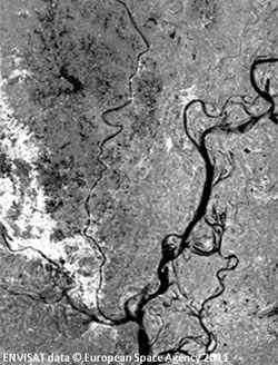
The archived data have a two-fold utility, firstly in the improvement of positioning accuracy in relative positioning mode; and secondly as a source for mining environmental variables such as atmospheric water vapour content and vertical land movement. BIGF is currently occupied in extracting these variables and providing them as quality assured products for on-use by scientists, example below.

See http://www.bigf.ac.uk
Spaceborne Synthetic Aperture Radar (SAR) sensors are becoming commonplace, with most of the world’s largest space agencies having at least one in orbit. Italy has an existing cluster of satellites with a SAR capability in COSMO-SKYMED, clusters are planned under the Canadian Space Agency’s RADARSAT and the ESA's SENTINEL programmes, and the UK has a programme to develop its own capability in Astrium/SSTL’s NovaSAR-S satellite.
The wide interest in SAR is underpinned by the need to develop advanced techniques needed to support new applications, and Nottingham is at the forefront in this. Our expertise lies in geometrical modelling of imagery and the development of rigorous software techniques to manipulate the data. We have a long-standing expertise in the ortho-rectification of such data, which is an enabling technology in many fields, like agricultural and forest monitoring, where integration with other types of geographic information is paramount. Knowledge of the geometry of SAR data has led us to develop an in-house expertise in radargrammetry (SAR stereo) which enables the extraction of 3D data from image pairs, useful for topographic and geological mapping. A further expertise that we have developed is in interferometric SAR (InSAR) where 3D information, and more specifically, changes in land level, may be determined to sub-millimetre accuracy.
We have our own research software, Punnet, which brings together much of our expertise in SAR, and is under constant development and refinement. Punnet is being applied to a wide-ranging set of applications that includes earthquake and landslide monitoring and the precise measurement of long-term building subsidence in the urban environment.
Satellite SAR data is available all over the world, so the applications of our SAR activities has a global reach. We have surveyed areas as far apart as the UK, Australia, Bangladesh, Jamaica, Indonesia and China for applications as wide ranging as climate change, sustainable agriculture and water management in urban areas. Most of this work has been sponsored by government agencies and research councils but we have also gained support from the commercial Earth observation industry.
Deformation Monitoring and Laser scanning
Recently, there have been significant advances in the spatial and temporal resolution of laser scanners. These have enabled new applications, for example, in the monitoring of railway infrastructure, where train mounted laser scanners, positioned using GNSS and inertial measurement systems, can be used to monitor the condition of tracks, tunnels, embankments and other infrastructure. This can aid the planning and scheduling of repairs. The Institute has an unique test facility on its roof-top for such research, in the form of a figure of eight track way and a track-mounted vehicle.
Current research is also considering laser scanning to monitor the slow deformation of buildings with time, using permanent targets, and in a latest development, evaluating laser signal intensity return as a means to identify structural weakness.
Mapping in Urban Environments
Many engineering surveying applications are concerned with the mapping and monitoring of assets and infrastructure, which are mostly found in densely populated urban areas. The most economic mapping and monitoring method is GNSS-enabled, however this may not always be possible, as the urban sky view is often obscured by buildings and vegetation.
To work around this, GNSS can be integrated with other sensors, such as inertial measurement systems, total stations, and pseudolite type positioning systems, for example Locata. Such integrations can not only improve accuracy, but also provide a more reliable and cheaper solution. The Institute carries out research into sensor integration and mapping for such difficult environments, with a particular focus on the mapping of underground utilities and new applications for augmented reality systems. (Locata is a ground based GNSS-like positioning system, essentially a local GNSS constellation).
Current Projects
- TREASURE: Training REsearch and Applications Network to Support the Ultimate Real-Tim High Accuracy EGNSS Solution. Funded by the European Union's Horizon 2020 Research and Innovation Programme. Project team: Dr Marcio Aquino
- BIGF: British Isles continuous GNSS Facility, sponsored by NERC, 2009-14. Project team: Richard Bingley, David Baker and Dionne Hansen.
- GeoSHM (GNSS and Earth Observation for Structural Health Monitoring), sponsored by ESA. Project team: Xiaolin Meng.
Past Projects
- Precise location measurement in indoor and outdoor performance sport, EPSRC industrial Case studentship with the English Institute of Sport; project team: Martin Smith, Bertrand Perrat, and Scott Drawer.
- Use of persistent scatterer interferometry for the enhancement of vertical land movement measurement of tide gauges around the UK, PhD studentship sponsored by NERC; project team: Andrew Sowter and Ligia Adamska.
- Flood risk management consortium, funded by EPSRC; project team: Michael Mawdesley and Martin Smith.
- Measuring changes in land and sea levels around the coast of Great Britain, Environment Agency; project team: Richard Bingley and Dionne Hansen.