Spatially-Aware Mobile Applications for Field Work
Overview
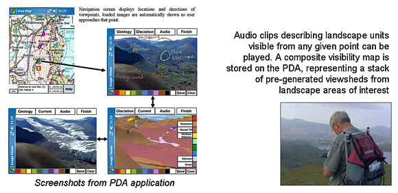
Through the SPLINT (SPatial Literacy IN Teaching) project we are developing strategies for using GPS-enabled mobile devices (PDAs, tablet PCs and phones) to enhance aspects of field work. Applications have been developed in the Visual Basic Compact Framework by Gemma Polmear including a PDA application to supply supplementary information of various types to the user relevant to their spatial context, not only their position but the area visible from that location. The application is designed for use in the context of a geography fieldtrip to allow students to directly compare computer generated landscape visualisations to their real world counterparts, as well as offering the same scene draped with geology or with a model of retreating glacial ice.
Related Outputs
Priestnall, G. and Polmear, G (2006) Landscape Visualisation: From lab to field, Proceedings of the First International workshop on mobile geospatial augmented reality, Banff, Alberta, Canada, 29-20 May 2006.[PDF]
Related Links
MSc in Geographical Information Science
www.splint-cetl.ac.uk |