Projects
Listed here are projects I am currently involved with in varying degrees, and also past projects.
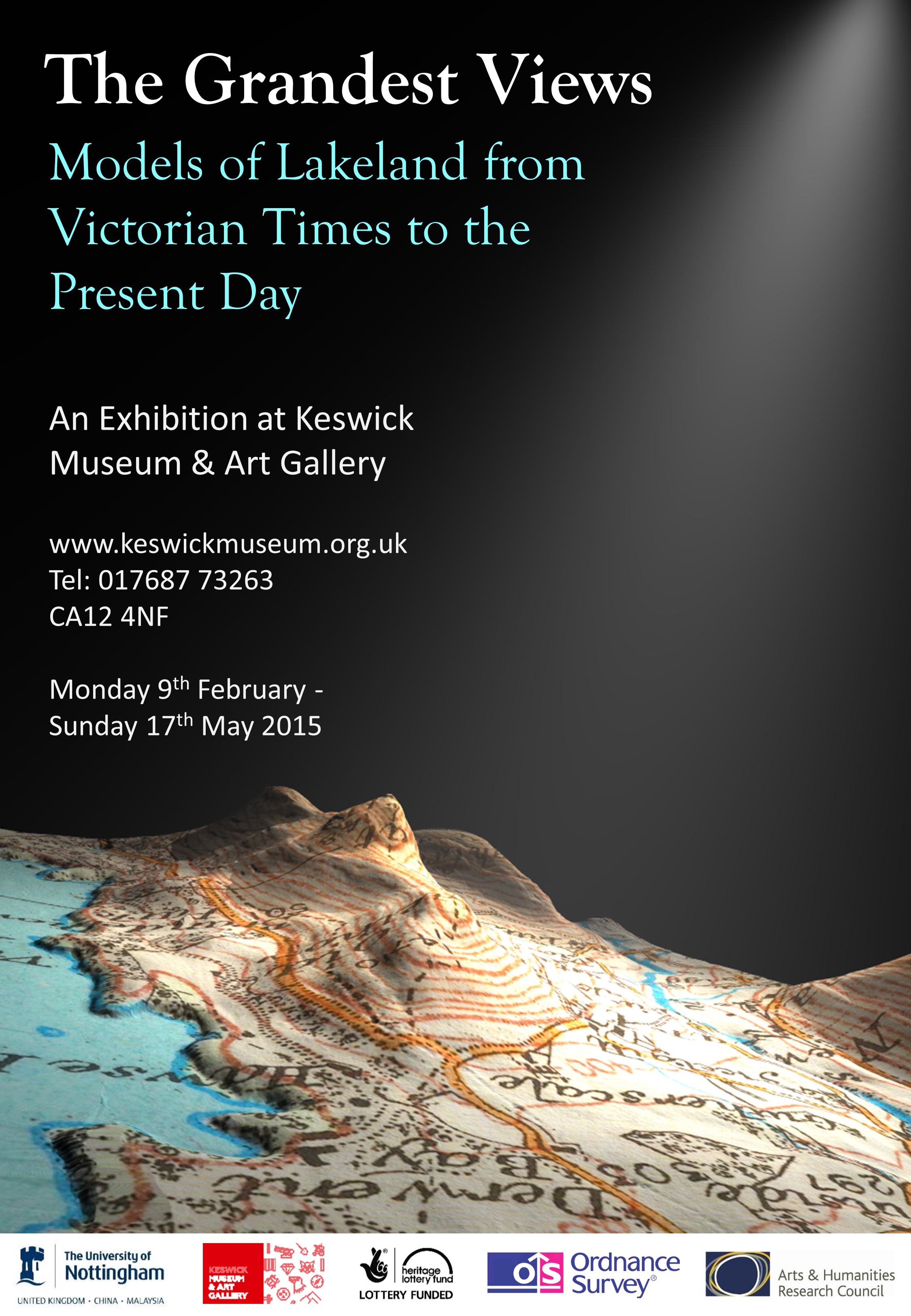
Mayson's Ordnance Model of the Lake District (and 'The Grandest Views' exhibition)
Reconstructing a Victorian Landscape Model based in Keswick, Cumbria
‘Spots of Time’
An interactive installation at the Wordsworth Trust, Grasmere, Cumbria
The Projection Augmented Relief Model (PARM) technique: Exploring the potential impact on the heritage and museum sector(2012)
Funded by Centre for Advanced Studies Research Development Fund.
Spatial Knowledge Acquisition: Exploring the Potential of the Projected Augmented Relief Model (PARM) technique (2012)
Funded by EPSRC Research Development Fund (Pump Priming section).
Measuring landmark saliency in the field (2011 - 2012)
Funded by University's Science Technology and Society Research Development Fund.
Zapp (2010 - )
Mobile Application developed by Sam Meek (PhD student)
Weather walks, weather talks: exploring popular climate histories and futures (2012 –2013)
Funded by AHRC.
Bridging the Rural Divide: Blueprinting the Rural Ubicomp Toolkit for Community Mapping (2010 - 2012)
Funded by the EPSRC
Savage Grandeur - Virtual Tour (2010-2011)
Collaboration with the Wordsworth Trust, Grasmere, Cumbria
Towards Pervasive Media (2010-2011)
Funded by the EPSRC
Digital Community History (2010)
Pilot project within Horizon Digital Economy Research Institute
Edward Lear Landscape Artist - Virtual Tour (2009)
Collaboration with the Wordsworth Trust, Grasmere, Cumbria
Augmenting the Visitor Experience (2009-)
Initial technical development part-funded through HEFCE SPLINT project
where:now (2009)
University of Nottingham Knowledge Transfer Award from HEFCE's Higher Education Innovation Fund
DEsign of Learning spaces in 3D Virtual Environments (DELVE) (2008-2009)
Funded by JISC. With Open University (lead partner)
FASTRAC - A Whole-site First-assessment Toolkit for combined Mineral Resource and Archaeological assessment in Sand and Gravel deposit (2007-2008)
Funded by English Heritage.
GeoSpatial Widgets (2006-2008)
Funded by the Visual Learning Lab (A HEFCE-funded CETL)
Mapping Performance Culture: Nottingham 1857-1867 (2006-2009)
Funded by Arts and Humanities Research Council.
SPatial Literacy IN Teaching (SPLINT) (2005-2010)
A HEFCE-funded Centre for Excellence in Teaching and Learning
University of Leicester (lead partner), University of Nottingham, and UCL
Flood Risk Management Research Consortium Work Package: Exploiting New Data Types (2004-2009)
Funded by EPSRC, DEFRA, EA
Representations of Embodiment: Implications for Fine Art and Geographical Information Science (2003-2005)
Funded by Arts Council England and the Arts and Humanities Research Board
Mapping Change (2001-2002)
Funded by South East Arts and Interreg
Real World Mapping (2000-2001)
Funded by Nottingham City Council
Automated Linear Feature Identification and Extraction (ALFIE) (1999-2002)
Funded by Qinetiq (formerly DERA)
The Raqqa Ancient Industry Project (1999-2002)
Funded by the Arts and Humanities Research Board
Automated land use change detection from maps and high resolution imagery (1996-1997)
Funded by the University of Nottingham
River Channel Adjustment on the Bollin (1994 - 1997)
Funded by the University of Nottingham |