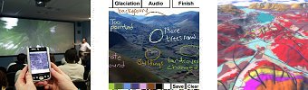
The integration of real-time Global Positioning System data with geographic information on mobile computers offers opportunities for field-based learning through the use 'spatially-aware mobile computing'. Some of the activities being developed relate to the positioning data and techniques themselves, others to their wider application. One example is the use of spatially-aware mobile computing to study land use change around the University Park campus. Experimental techniques being developed include the use of Personal Digital Assistants (PDAs), tablet PCs and Head-Mounted Displays (HMDs) to allow past environments (such as glaciated landscapes) and hidden landscapes (such as sub-surface geology) to be visualised in real-time out in the field. In addition to serving up information relevant to the spatial context of the user such techniques allow the capture of any aspect of the surrounding environment including the students’ own experiences of a landscape. Another major focus for Nottingham SPLINT activities is the development of good practice in the use of 3D visualisation including the use of a stereo semi-immersive visualisation facility. Work flows for the creation of 3D models of the University campus and key field work sites are being developed and integrated into the curriculum. One building on campus (Portland) is shown below in Google Earth. The way in which students can orientate themselves in a virtual environment and therefore utilise the techniques effectively is of interest, and an early example is the visualisation of possible wind farm locations in Cumbria as part of a broader site suitability exercise. This exercise will also become the focus of the Nottingham arm of the DELVE project by exploring techniques for collaborative visualisation of this landscape and problem domain within the online virtual world Second Life. An aim of SPLINT at Nottingham is to explore the application of spatially-aware mobile computing and 3D visualisation beyond the disciplines of geography and engineering and collaborations are being developed with other schools including Archaeology and Art History. Research Outcomes (see SPLINT web site for all consortium outcomes) Jarvis, C, Priestnall, G., Polmear, G. and Li., J (2008) Geo-contextualised visualisation for teaching and learning in the field Geographical Information Science Research UK (GISRUK) Conference, 2 - 4 April 2008, Manchester Metropolitan University [PDF] Smith M J, Burton A., Kokkas. N., Priestnall G., and Polmear. G (2008) Raising spatial and visualisation awareness in a teaching environment The XXI Congress of the International Society for photogrammetry and Remote Sensing , 3-11 July 2008, Beijing, China. Priestnall, G. and Polmear, G (2007) A synchronised environment for developing spatially aware mobile applications , Proceedings of the 15th Annual Geographical Information Science Research UK Conference (GISRUK ’07), Maynooth, 11-13th April 2007 [PDF] Priestnall, G. and Polmear, G (2006) Landscape Visualisation: From lab to field, Proceedings of the First International workshop on mobile geospatial augmented reality, Banff, Alberta, Canada, 29-20 May 2006.[PDF] Priestnall, G. and Polmear, G (2006) A spatially aware mobile test bed for exploring and enhancing spatial literacy skills, Proceedings of the 14th Annual Geographical Information Science Research UK Conference (GISRUK ’06), University of Nottingham, 6-8th April 2006 Related Links |