Current research project: GRASP-GFS
GRASP-GFS - Geospatial Resource for Agricultural Species and Pests with integrated workflow modelling to support Global Food Security: a prototype.
Access to wide ranging information, from scientific results to local farmer’s knowledge, is crucial to planning food security, from community to national levels. Intrinsic to this, is the fundamental challenge to design scientific and intervention strategies within changing climates and markets. Research in agriculture is also changing, with developments in data collection through mobile communications, sensor platforms, spatial search, and pervasive computing.
However, inter-disciplinary research needed to transform raw data into useful intelligence, to improve the planet’s environmental, economic and societal well being, remains constrained by a range of barriers - disciplinary, organisational, historical, and a non-existent or non-rigorous approach to quantifying uncertainty in collected datasets.
GRASP-GFS will use a geospatially orientated database to query such multi-dimensional data - including scientific papers, reports, and socio-economic and local knowledge. This framework will enable weighting of the components within a chosen geo-workflow model for food security, which will be developed using cross-disciplinary expertise from geospatial science methodologies.
The driving focus will be the agricultural species germplasm for genotype characteristics, with the data ordered by geospatial origin. A novel aspect of this is combined data use, from climate records or scenarios, ground condition, crop traits, and agriculturally important animal and microbial species.
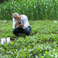
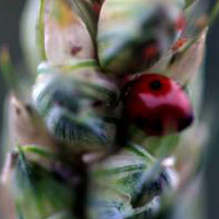
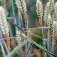
Figures, left to right: Experimental bambara groundnut planting; Adult ladybird feeding on aphids on a
wheat head infected with Fusarium spp; Wheat infested with aphids.
This approach will give new perspectives on genetic diversity, identifying new sources of germplasm and trait variation, geolocating suitable germplasm by agro-ecological modelling and matching, and planning breeding objectives with the greatest likely impact.
Modelling capabilities will be developed using a generic approach to frame each model, allowing workflow development based on semantic descriptions of data and processes, with workflow quality assessment for uncertainty/error propagation.
Two case studies will be used to demonstrate this approach - wheat production in the UK, and bambara groundnut production in Malaysia. This will involve crop specific data and processing models to forecast geospatial trait variation for each crop.
GRASP will support the Crops for the Future Research Centre (CFFRC) in Malaysia, allowing investigators to shape data handling and integration according to their needs, then contributing to the prototype database population. Data capture will include sensor networks, remote sensing, and crowd-sourcing from farmers. Integrating these data via the GRASP platform, will enable refinements to workflow modelling and multi-scale scenario risk assessments.
Using open standards and interoperability principles developed by the Open Geospatial Consortium (OGC), the platform deliverable software will be released under open source license. Desktop interfaces and web interfaces with compiled updatable databases will be released, enabling the widest usage, including remote locations with weak internet connections.
GRASP-GFS aims to link with other global initiatives such as GEOSS (Global Earth Observation System of Systems) and GeoNode, to develop productive interactions between bench, economic and social scientists.
Project contact: Didier Leibovici