Skills required
Maps and plans represent a specialised medium, often created by specialists, and so users will sometimes need particular skills in order to gain the most out of them. However, the key features to look out for are:
If a map or a plan includes a title, this makes life a great deal easier for the user. It will hopefully tell the user 'what', 'where' and 'when'. Where a title is present, caution should still be applied, however - it may be obscure, relating to the particular purpose for which the map or plan was created, the context of which has now been lost; or the map or plan may be a copy from an earlier document, meaning that the date included is not representative of the date it was first constructed.
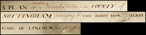
Detail from a plan showing land in Newark Fields, Nottinghamshire, belonging to Henry [F.C. Pelham-Clinton, 9th] Earl of Lincoln; n.d. [pre-1768] [Ne 6 P 3/15/3]
Orientation
Many maps and plans are constructed with north at the top. Users are advised, however, to look for a compass rose or other symbol which may show an alternative orientation. If one is present, it might be helpful to rotate the map or plan (if space allows) so that the compass is pointing north.
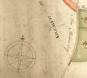
Detail from a map showing the compass [Ne 6 P 3/15/3]
Scale
Most maps and plans will include some sort of a scale to assist the users in making judgements about sizes and distances. Some of these will be easy to interpret - six inches to a mile, for example. Others, involving measurements such as roods and chains, will prove more challenging. Yet others may be represented graphically, using a calibrated bar.
The sources available in the bibliography contain information about scales, and users are also advised to consult glossaries/dictionaries of old weights and measures.
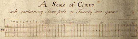
Detail from Ne 6 P 3/15/3 showing the scale
Legend or key
Some maps and plans will include a legend, or key, which explains the symbols and colours used in the document. Users should always look for this, as it will greatly assist in their interpretation if it is present. Particular boundaries may be marked in one colour, for example, land on which corn is grown may be marked in another, land belonging to one particular person might be marked in another way. There may also be symbols to represent particular features such as windmills, river crossings, telegraph poles, pylons etc. Where a legend or key is not present, standard works may again prove to be a source of information.
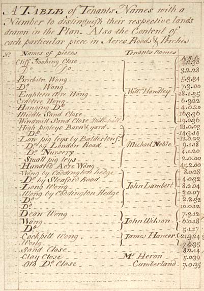
Detail from Ne 6 P 3/15/3, showing the key that associates a number with the name of a particular tenant
Name of cartographer
Or of surveyor, architect or engineer. This may be a useful detail to have. If something about the map or plan is unclear, for example, it may be helpful to compare it with other maps and plans by the same person.
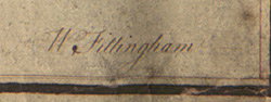
Detail from Ne 6 P 3/15/3 showing the surveyor's name
Other names
The map or plan may include names of financing, sponsoring, controlling or commissioning agencies. Where this is the case it may help to provide an indication of why and it was produced or the context in which it was later used.
Other points to bear in mind
When assessing the value of a map or plan and the information contained within it, users should always bear in mind the purpose for which it was originally created. The mapmaker may have had a vested interest in ensuring it was perceived in a certain way. It is possible that the plan could have been created entirely for propaganda purposes, or even to provide false information for espionage. The map or plan may have omitted details because they were not relevant to the purpose in hand. The omission of particular features, however, does not necessarily mean they were not there. It is important always to consider what is not shown and why. Users should always try to bear in mind the context in which a map or plan was created, and the fact that they may be giving it an entirely new purpose as a result of their research.
- Another point for users to bear in mind is whether the map or plan they are using may have been based on, or copied from, an earlier document.
- Using maps and plans may present a physical challenge to the researcher. Some are extremely large in size and very cumbersome to handle and consult. If stored in a roll, they may need to be weighted down - something which may obscure a full view of the map. If large in size it is highly unlikely that maps and plans can be copied for future reference. Users may, however, be able to make tracings from the map under specially managed conditions. If so, they will need to consider the equipment needed for this purpose.
- Users of maps and plans should always look at the cartouches and vignettes for any additional information which may be of relevance. Where these are present, it is worth bearing in mind that they provide a stylised image rather than a faithful depiction.
- Finally, users of maps and plans are advised always to look beyond the obvious - for example, if you are interested in the history of a particular property, it is always worth looking at a map or a plan of a neighbouring property for any details which might be included!
Next page: What Can We Learn From Maps and Plans?